
Creating a Stat Nav Itinerary Route
I believe being competent at reading a map is something that is either in your genes or it's not. It's simple, you are good at it or you are not. Therefore why people take Maps with them on tour as their only form of navigation is beyond me. In fact I haven't taken a map on any of my European trips since 2005, relying solely on Satellite Navigation to see me through. This isn't because I am bad at map reading, it's simply because I want to enjoy the route and not be worried where the next turning is. I am certain that the main reason I am still married is because of my 'Trusty Sat Nav'. Arguments surrounding navigation are just not on the agenda.
Now if you are the type of individual which wants to go from point A to point B and are not bothered how you get there, then any Sat Nav will be perfect for you. However if you are like me and want to see the country between point A and Point B, which is not on the Fastest Route, then a different approach has to be taken. Generally speaking, you will need to look elsewhere than the standard Sat Nav but let me explain as it easier than you think....
Start planning your trip long before it starts at Home with Google Maps. Using it's Routing Capability ask it to plot the fastest route between the two places you expect to travel between on any given day. My general rule of thumb here is that Google's Fastest Route estimation, between the the two locations, should be a very easy day's drive perhaps as little as a four hours.
Then the interesting bit starts. Searching Google Maps,using it's Map, Google Earth, Imagery capability, Wikipedia and the Web, work out what you are missing out on by going on the Fastest Route. Once again the general rule of thumb is you need to be going in roughly the same direction.
Then with a clear understanding of where you would like to go between Point A and Point B load up Tyre. Tyre is based on Google Maps, you will find it very recognisable and is FREE although you can subscribe to it for a minimal fee / annum which will cut out the advertisements. Tyre is written to run on Microsoft Windows so If you are running a Apple laptop then you will need to use a Virtualisation Program.
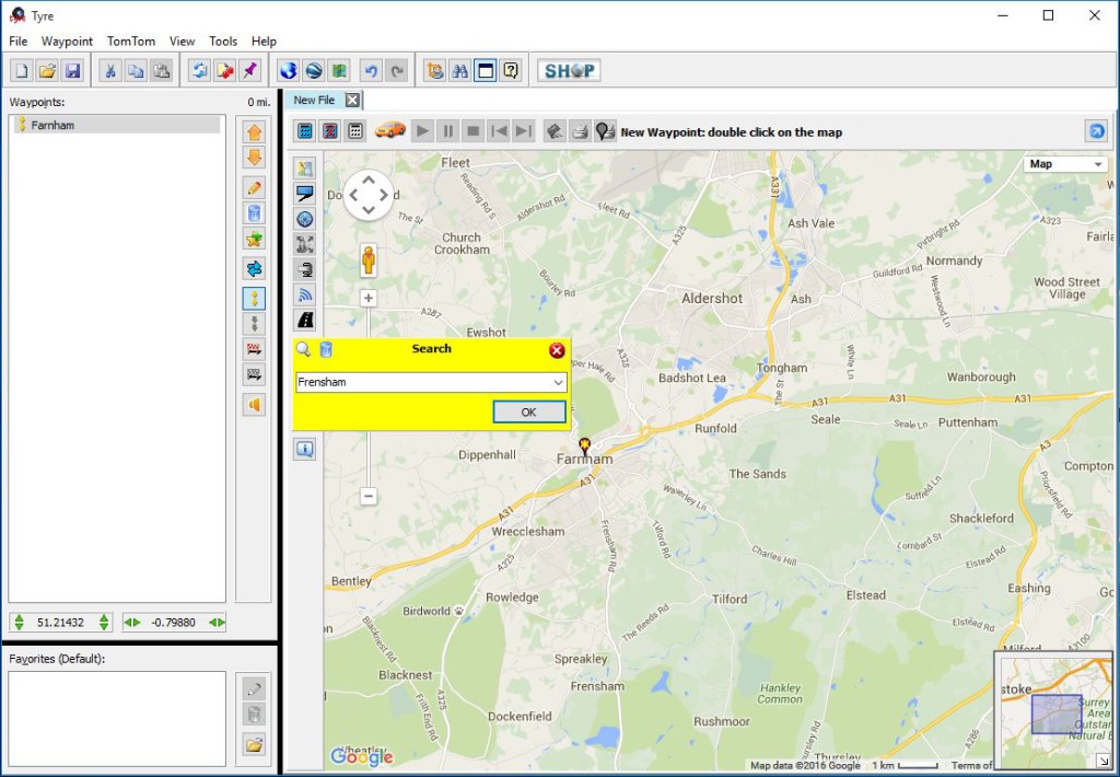
With Tyre running, then plot your beginning and end locations using its Location Finder (the little Magnifying Glass icon) and add the two points to your itinerary in the left hand window.(Figure 1)
Figure 1.
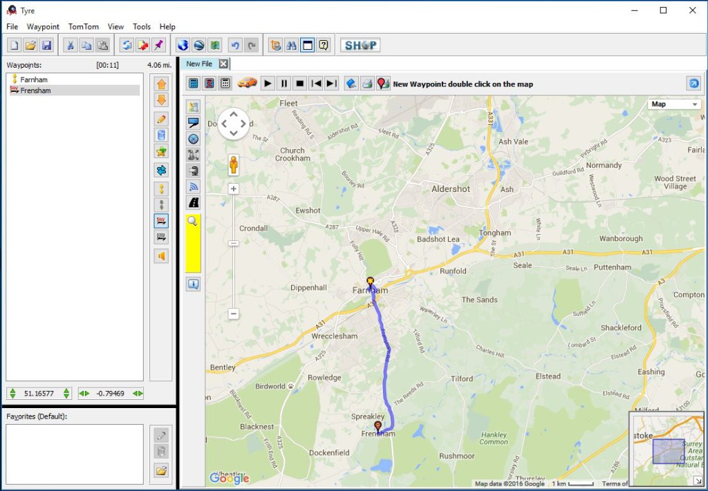
The Fastest Route will be displayed as a blue line between the two points in the map window. The distance and estimated duration of your trip is displayed in the top of the Itinerary Window for you. (Figure 2)
Figure 2.
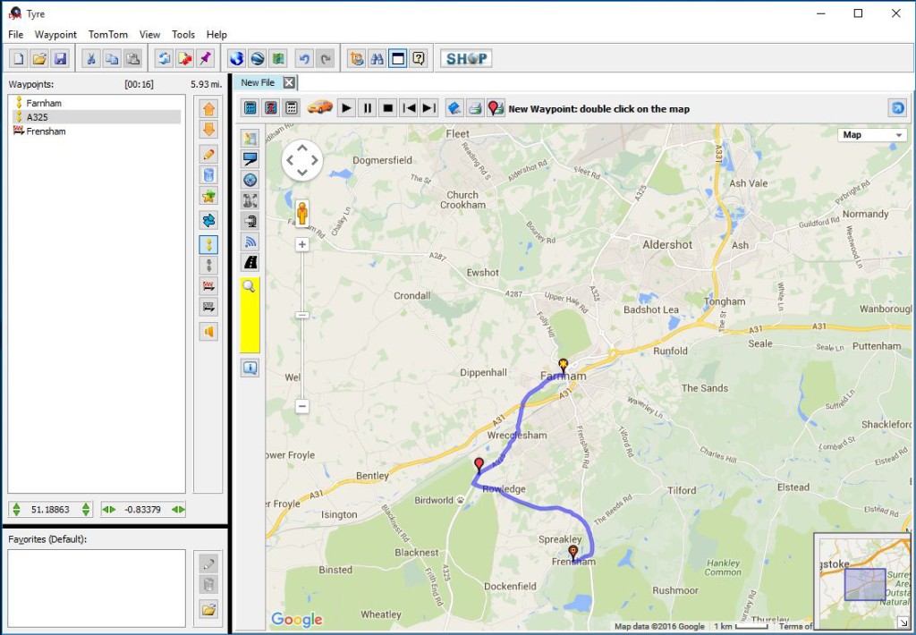
In the Map Window, click anywhere on the blue "Fastest Route" line and drag to your first point of interest, a town or place or even just a road you want to travel along and a Waypoint will be created. Tyre will now update the route in the Map Window to include the additional waypoint you have created, along with updating the Itinerary log and the amended distance and duration of your trip. (Figure 3). There is a limit of how may Waypoints you can have. This restriction is not in Tyre but the Sat Nav systems you can export your Itinerary File to. So as a rule of thumb consider 48 as the maximum.
Figure 3.
My advice would be to keep things on a day to day basis so that each tyre file represents one full days travel. As you create each day save them as the itinerary file specific to your Sat Nav using a logical naming convention "Day01 - Farnham to Frensham" etc.
One further point of advice on Tyre is that, as it sits on Google and it's routing is defined by Google Maps, Google Maps will only route you via a high pass during the Summer as the road is probably shut in the Winter.
All my experience has been TomTom related so if you are using a Garmin or other the next section may well be different. The other word of warning around TomTom is that TomTom in their infinite wisdom discontinued the "Itinerary External Load" feature in their more modern devices. Old variants are still available on eBay as people sell them off as they either upgrade their units to more modern units or now have in Car Stat Nav and believe their trusty TomTom is surplus to requirement.
So with a compatible TomTom device connect it up to your PC running the Tyre software. If TomTom Home loads close it down as you will not be needing it. Open up Windows Explorer and copy the TomTom itinerary files you have create and copy them to the itn folder on your TomTom device. Then disconnect your TomTom device from your PC, wait for it to reboot and load up your first itinerary and enjoy the drive....